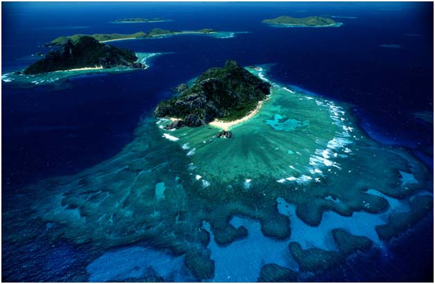
It is no more than a spec in the globe..............
It is in the pacific...........
It has two main islands...........
It is a paradise.....
Not quite!!!!
Mataisau compiled a report on some of the community visits.
Community Mapping Report
This is a report compiled from 19 communities from 30th May to Tuesday, June 28, 2011, through community mapping.
Lami area consists of 8 communities:
 |
Satellite view of Lami area
Source: Google Maps |
Lami
· Wainivokai
· Wailekutu Tiri
· Wailekutu Vanua
· Osonabukete
· Vuniivi
· Mataniborosisi
· Bilo
· Waibola
Five communities from the Vatuwaqa Area:
Vatuwaqa
· Korova
· Veidogo
· Nanuku
· Nakelo
Three communities from the Laucala Beach Area these are:
Laucala Beach
· Maravu 1
· Maravu 2
· Maravu 3
The last four communities are from the Caubati Area these are:
Caubati Area
· Caubati Koro
· Caubati Mamas 1
· Caubati Mamas 2
· Caubati Veiniu.
Community Profile
Vunimoli
Vunimoli is a small settlement that is on crown land it consists of 32 houses. These are some of the problems and some solutions the community came up with:
This community has the problem of erosion of their shoreline.
Some parts of the community is as it is shown above, rather than waiting for help from the government and other organizations the community helped themselves by placing used tires along the shore lines and also they have buried some places with unused concrete from the Suva Prison.
Some of the parents cannot afford to send their children to school, so most of the teenagers are at home and plant at their plantation. Some of the other families along with their children plant flowers to sell in the market.
Apart from these problems the community have drainage problem, poor road conditions and unemployment is a main concern.
Most of the community members depend on the sea for food and it is also a source of income. The other source of income that we saw in the community is the making Sasa brooms from coconut leaves and to sell them. With everything stated above the members of the community came together to make up their community map:
Wainivokai
The second settlement that we went to was Wainivokai is a settlement that consists of 14 houses; the settlement sits on State Land. The settlement has certain problems and the main problem is the flooding:
The other problem is the Drainage problem, in times of heavy rain the drainage would not help stop the flooding but cause flooding of the houses in the settlement.
With the Fiji Fish Factory (local fish factory) and the Cement Factory being close to the Wainivokai Settlement, most teenagers have given up their education to work in these factories.
After discussions the community members they drew up their community map.
Wailekutu Tiri
Wailekutu Tiri settlement is on state owned land. It faces the similar problem as the previous community since it is also close to the sea. There are 15 houses at this settlement.
This settlement usually face flooding since it is close to the sea, the other problem at this settlement is the rubbish that is washed into the community when there is heavy rain and also when people dump rubbish into the river and it is washed in to the sea.
These are some of the pictures at the Wailekutu Tiri settlement:
This is the community map for the Wailekutu Tiri drawn by the people:
Wailekutu Vanua
Wailekutu Vanua is just beside Wailekutu Tiri, with the main highway parting them. This community consists of 23 houses. Shown below is the road system of Wailekutu Vanua.
This community however needs proper drainage system, and also the roads are not so good.
Wilekutu community map:
Osonabukete
Osonabukete consists of 31 houses, this settlement is on Native Land and the people living in this area pay $160 a year.
These are some problems the people of Osonabukete face:
The main problem for this settlement is the road especially when it is rainy season the track up to the settlement is very bad and very steep.
The community has come up with some solution to their tracks they have used concrete to help them walk up to their houses.
The other problem the community faces is the water problem they don’t have water coming from the main. The community has solved this problem by buying water tanks to collect rain water for them to use as drinking water and also for cooking.
The main priority of this settlement is to get a place they can reside in without any problems and they are willing to do anything to get a secure land. After discussing with them the community came up with their community map:
Then we visited Bilo Road which had three settlements in the area, this settlements are:
· Bilo Settlement
· Vuniivi
· Mataniborosisi
These settlements are located on the roadside, along the main road from Navua to Suva. They also face similar problems like their neighboring community.
Maravu
Maravu settlement is on a state owned land and is divided into three; Maravu 1, Maravu 2 and Maravu 354 houses. It is located near Samabula River, just outside the industrial factories and few kilometers away from Nasinu Town. The settlement is built on tiri land (Mangrove Swamp land). The members look for work in the nearby factories or in the local town for daily income. Some members resort to fishing from the river and farming in vacant lands nearby.

The community faces the common problem of flooding from the river during rainy season and also from improper drainage. Water is stored in the compounds causing the grounds to be boggy. Also this causes the road access to be consistently muddy and be in unusable state.
Evenmore the community also face littering problems. With no access to rubbish collection or proper rubbish disposal, the community dumps their rubbish in the river which gets washed up back to their shore. Initiative to overcome this littering problem by the community has been futile. The team realized that the community members play the blame game on each other and not taking responsibility to better their community.
However in our last visit, the members have been warned, and members are to keep a look out for litter bugs, if offenders are caught they are to be reported to the P.C.N office and they will be referred to relevant authorities.
Conclusion
Furthermore, it was identified that some houses were missing from the previously compiled community maps. This was due to previous compiled maps, only had the P.C.N member houses in the community whereas, the non-members were disregarded. As, during the cause of the recent mapping, it was ensured that everyone in the community were included and thus caused a difference in the statistics of the previously compiled report.
Also, it was identified that some communities were mis- identified. That is, two or three separate communities identified under one name. Such was the case of Maravu, which had three communities identified under one name.
Moreover, we noticed that communities did not fully understand the purpose of community mapping that is to get a brief of what their community layout is and also help them identify some of the problems that are in the community and try to figure out how they can solve these problems.
Even with the disturbing reality it is still....OUR ISLAND HOME....